
English| EUR
Suggested for you
More currencies
Choose a language
Roughly ninety kilometres of eucalyptus track, granite waymarkers and Atlantic weather separate the cathedral from the lighthouse at Cabo Fisterra, on the edge of the Costa da Morte. This Santiago to Finisterre stages guide sets out how walkers usually divide that distance, where the Camiño de Fisterra forks toward Muxía, and what the cape asks of you on arrival.
Quick answer
Most walkers cover the roughly 90 km from Santiago de Compostela to Cape Finisterre in three or four days, commonly breaking at Negreira, Olveiroa and Cee. The cape itself imposes no schedule: the lighthouse grounds on the AC-445 are public, open around the clock, and free at 0 EUR. The one caveat is the Hospital crossroads, where the waymarking divides toward Muxía.
Every other Camino ends at the cathedral in Santiago de Compostela. This one begins there. The Camiño de Fisterra is the only waymarked branch that carries walkers away from the tomb of the apostle, west toward the Atlantic, and it follows a path that predates the medieval pilgrimage entirely: Celtic and Roman travellers already came to this headland to watch the sun drop into the ocean, a rite remembered as the Ara Solis. Anyone comparing Santiago to Finisterre stages is planning a journey with two endings — one behind, one ahead. The distance is about 90 kilometres of Galician back country, and the terrain does more to shape a walker's plan than the mileage does. The route leaves the city through eucalyptus and pine, crosses the medieval bridge at Ponte Maceira, and climbs onto open hill country beyond Negreira. Granite mojones — the squat waymarkers topped with a scallop shell — count the kilometres down rather than up, which changes the psychology of the walk. The waymarking is continuous but sparser than on the Camino Francés, and villages with services sit further apart. Past the hamlet of Olveiroa the land flattens into moorland, and at the Hospital crossroads a single marker splits the Camino Finisterre in two: left for Cabo Fisterra, right for Muxía. Only after the descent into Cee and Corcubión does the Atlantic appear, with Praia de Langosteira curving toward the last climb. What the answer is worth, practically, is a choice about pace. Walkers carrying a credencial collect stamps along the way and can claim the Fisterrana at the pilgrim office in Fisterra town, which sits below the AC-445 as it climbs to the headland. The cape at the top of that road is not an attraction with a gate; it is a working lighthouse on public ground, and the crowds that gather at the 0.00 km marker in high summer thin out within an hour of dark. Many walkers add the coastal link to Muxía afterwards rather than treating the lighthouse as the finish, which turns a three-day plan into five. Read the Santiago to Finisterre stages set out on this site alongside the seasonal notes, then choose the split that matches your own daily distance rather than the one printed in a guidebook.
“The Camiño de Fisterra is the only waymarked branch that carries walkers away from the tomb of the apostle, west toward the Atlantic.”
This four-day plan suits walkers with moderate fitness who want to continue west from Santiago de Compostela to the Atlantic coast, covering roughly 90 km on the Camino Finisterre. Each stage runs 20-35 km, ending in a village with albergues and small guesthouses.
Leave the Praza do Obradoiro and follow the waymarks through Ponte Maceira, a medieval bridge over the Tambre, to Negreira — about 21 km over rolling ground. The climb out of Santiago via Sarela de Abaixo is the steepest part of the day.
The longest stage at roughly 33 km, crossing open farmland and hamlets such as Vilaserío and Santa Mariña. Water points are sparse between villages, so fill up whenever you pass a fountain.
About 20 km, passing the Ermida das Neves and the Alto da Cruz, where the Atlantic first comes into view above Cee. Many walkers stop in Cee or continue 2 km further to the harbour town of Corcubión.
A 12-15 km coastal stage through Estorde and Sardiñeiro, ending at Praia de Langosteira and the town of Fisterra. Most people arrive by early afternoon and leave the lighthouse for later in the day.
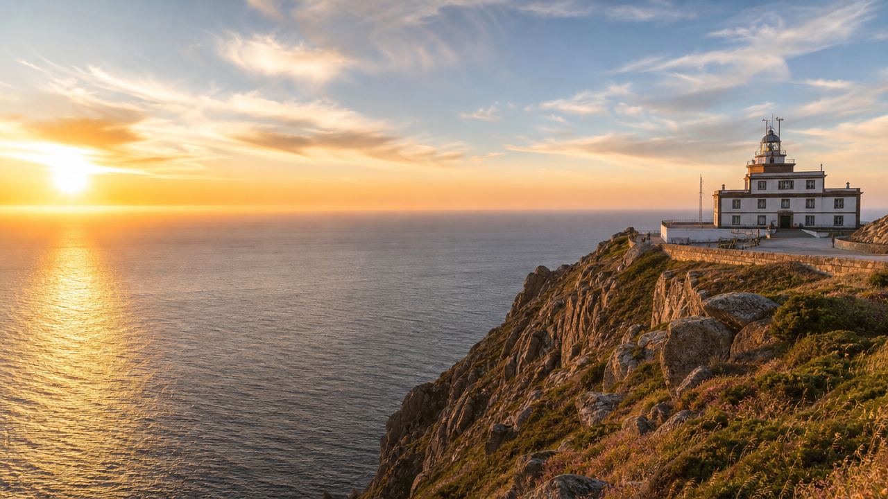
The final 3.5 km walk uphill along the AC-445 to the lighthouse at Cape Finisterre, marking kilometre 0.0. Allow about 45 minutes each way, or an hour if you stop at the Monte do Facho viewpoints.
The period from May to September offers the most stable conditions for walking the stages, as these months provide daylight hours that favor outdoor activity. For the final arrival at the lighthouse, the best arrival window is 00:00–23:59, specifically during sunset for the clearest view of the horizon.
Mild, 15°C to 22°C
Longer days and pleasant temperatures facilitate walking. These months avoid the peak summer density.
Warm, 18°C to 25°C
This is the warmest period. Expect higher trail usage and busier conditions near the coast.
Cooler, 12°C to 19°C
Trails are quieter during these months. Rain probability increases as the season progresses.
—
The cape is a public space best visited at sunset for its scenic views.
Verdict: The best time to walk the stages is from May to June or September to October, aiming to arrive at the lighthouse during sunset.
Cape Finisterre is located at the end of the peninsula in A Coruña, Spain. Visitors typically access the lighthouse via the local road network or the final walking segment of the Camino.
Monbus line from Santiago de Compostela to Fisterra
AC-445 to Fisterra
Follow the Camino signs to the lighthouse
The cape is a public space best visited at sunset for its scenic views. The address is AC-445, 15155 Fisterra, A Coruña, Spain.
The grounds at Cape Finisterre are accessible to visitors every day of the week. As a public space, the area remains open at all hours.
Preparation for the Camino Finisterre matters more than for the Camino Francés, since services thin out west of Santiago and the final approach to the cape is exposed.
Everything you need to know about santiago to finisterre stages
Most pilgrims complete the journey in three to five days depending on their pace and individual itinerary choices. Planning the santiago to finisterre stages allows you to customize your daily mileage based on accommodation availability in local villages.
Access to the lighthouse grounds is completely free of charge. You can explore the exterior area and enjoy the coastal views without any entrance fee.
The best arrival window is 00:00–23:59, though many travelers aim for sunset to experience the coastal atmosphere. The cape remains a public space open at all hours for visitors to enjoy the scenery.
Yes, the area is open Monday through Sunday, 00:00–23:59. Because it is a public space, you are free to visit the landmark at any time that fits your schedule.
The route is generally suitable for families, provided you break the santiago to finisterre stages into manageable daily distances. Be sure to evaluate your group's fitness level, as the terrain varies between forest paths and coastal roads.
Pack sturdy, broken-in hiking boots, moisture-wicking clothing, and a reliable rain jacket given the unpredictable Galician weather. Do not forget to carry sufficient water and a map or GPS device to help navigate the different trail segments.
A frequent error is underestimating the hilly terrain found in the final section of the route. Proper training and careful pacing during the initial days ensure a more enjoyable experience upon reaching the Atlantic coast.