
English| EUR
Suggested for you
More currencies
Choose a language
Most pilgrims stop at the cathedral in Santiago de Compostela; a smaller number keep walking west for roughly 90 kilometres until the pavement runs out at the Atlantic. This page maps that continuation — the Camino Finisterre — from the Praza do Obradoiro to the cape at AC-445, 15155 Finisterre, A Coruña, Spain. You will find the stage breakdown, the distances between them, and the waymarking details that trip people up.
Quick answer
The route runs about 90 kilometres from Santiago de Compostela to Cape Finisterre, most commonly divided into three to five walking stages via Negreira, Olveiroa and Cee. The cape itself charges 0 EUR — free entry to the Cape Finisterre site and surrounding area — and the headland is open 00:00–23:59 every day, so arrival timing matters more than any gate.
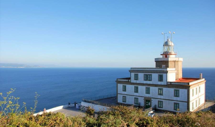
The scallop shells on this route point the wrong way. On every other Camino, the shell's rays converge toward Santiago; west of the city, the waymarking was laid out for walkers heading away from the cathedral, and the concrete mojones frequently confuse those reading them by old habit. A santiago to finisterre walk route map is therefore less a luxury than a correction — it tells you which of two diverging arrows belongs to your direction, particularly at Hospital, where the path splits toward Muxía or the cape. What the reader is dealing with is a continuation, not a separate trail. The route leaves the Praza do Obradoiro, drops through the Ponte Maceira bridge over the Tambre, and climbs into inland Galicia — Negreira, Santa Mariña, the long moorland stretch above Olveiroa. There are no cities after Santiago. Villages carry a handful of albergues, one bar, sometimes neither. The terrain is gentler than the Camino Francés but wetter underfoot, and the eucalyptus plantations that dominate the middle stages give little shade in an August heatwave and turn to running mud in a February one. The last day is the one people remember. From Cee and Corcubión the ruta xacobea a Fisterra turns coastal, passing Langosteira beach before the final climb along the AC-445 to the lighthouse, the Faro de Fisterra, and the 0.00 kilometre marker that ends the waymarked Camino de Fisterra. Beyond it sit the granite cliffs the Romans called Finis Terrae, the end of the earth, and the Costa da Morte shoreline that earned its name from centuries of wrecks. Muxía lies a further 30 kilometres north, and many walkers link the two sanctuaries rather than choosing. Used properly, a santiago to finisterre walk route map is a decision tool rather than a navigation aid. It shows where the bed shortage bites, which stage exceeds 30 kilometres, and how far a walker must go before the next open kitchen. Read it before booking anything: the stage lengths dictate the number of nights, and the nights dictate everything else about the week.
“West of Santiago the shells point outward, and the walker who reads them by habit walks back the way they came.”
This plan suits walkers of moderate fitness covering the Camino Finisterre on foot from Santiago de Compostela to Cape Finisterre, roughly 90 km over three to four walking days. The stages below use the standard overnight towns, so each day ends where beds, food and waymarking are reliable.
Leave Praza do Obradoiro, cross Ponte Maceira and follow the Tambre valley to Negreira, about 21 km over 5 to 6 hours. The climb out of Santiago through Sarela de Abaixo comes early, so start before the day heats up.
A long 33 km stage through Bardullas, Santa Mariña and the Xallas uplands, roughly 8 hours. Services thin out after A Pena, so carry water and food for the middle section.
Climb past the Ermida de Nosa Senora das Neves and the Marco do Couto to the first sight of the Atlantic, then descend to Cee and neighbouring Corcubion, about 20 km in 5 hours. Splitting the day here leaves a short final stage.
Walk the coastal path through Estorde and Sardineiro to Praia de Langosteira and into Finisterre town, roughly 12 km in 3 hours. Leave your pack at your accommodation before the final ascent.
Follow the AC-445 road up 3.5 km from the town to the cape, allowing an hour each way, and collect the Fisterrana certificate in town if you want documentation of the walk.
Walk out past the lighthouse to the 0.00 km marker and Punta do Faro for the western headland views, allowing 45 minutes at the point before heading back down to town.
Cape Finisterre is located on the Atlantic coast of Galicia, accessible from Santiago de Compostela via established regional transport links. Most travelers begin their journey in Santiago before utilizing public transit or private transport to reach the endpoint.
Monbus line from Santiago de Compostela Intermodal Station to Finisterre
Driving via the AC-445 road towards Finisterre
Private transfer from Santiago de Compostela to Finisterre
For the optimal light for photography and peak sunset viewing experience, plan your arrival to the site between 06:00 and 22:00.
The period between May and September offers the most stable conditions for walking the route to Cape Finisterre. For your final arrival at the Cape, the optimal light for photography and peak sunset viewing occurs within the 06:00–22:00 window.
Mild, 15°C to 20°C
Ideal temperatures for long-distance walking before the peak summer heat.
Warm, 20°C to 25°C
This period experiences the highest volume of pilgrims and warmer coastal weather.
Cool, 12°C to 18°C
Stable conditions with reduced foot traffic provide a quieter atmosphere for reaching the coast.
—
Arriving during early hours ensures fewer people at the monument for photography.
Verdict: The best time to reach the Cape is between May and October, specifically arriving during the 06:00–22:00 window to experience the best light and sunset conditions.
The Cape Finisterre site remains accessible to visitors throughout the entire week. These hours allow for flexible arrival times when navigating the route from Santiago.
The 90 km walk from Santiago to Finisterre rewards a few weeks of deliberate preparation, from credential paperwork to broken-in footwear.
Everything you need to know about santiago to finisterre walk route map
You can obtain a santiago to finisterre walk route map through official pilgrim offices or digital GPS tracking applications designed for the Camino. Many hikers prefer utilizing a printed santiago to finisterre walk route map to navigate the waymarked paths across Galicia. Always ensure your santiago to finisterre walk route map is updated to reflect current trail conditions or seasonal diversions. Using a detailed santiago to finisterre walk route map helps pilgrims maintain their pace while enjoying the coastal scenery of this historic route.
Entrance to the Cape Finisterre site and surrounding area is 0 EUR. There are no ticket requirements for visiting the lighthouse or the scenic cliffs at the end of the pilgrimage.
The best arrival window for visiting Cape Finisterre is 06:00–22:00. This timeframe provides optimal light for photography and the peak sunset viewing experience.
Yes, the path is well-marked with the iconic yellow arrows characteristic of all Camino de Santiago routes. Local waymarkers and signage serve as an effective guide for those walking the Camino de Fisterra toward the Atlantic coast.
The site is accessible daily with opening hours of 00:00–23:59 from Monday through Sunday. Visitors can arrive at any time, though sticking to the recommended daylight window is advised for safety.
The trek is physically demanding, involving significant daily distances over varied terrain. Families should assess the fitness levels of younger participants before committing to the full multi-day walk.
Preparation involves verifying your gear, checking the weather forecast, and ensuring you have sufficient water supplies. Hikers should also research accommodation availability along the trail to ensure a comfortable journey to the coast.